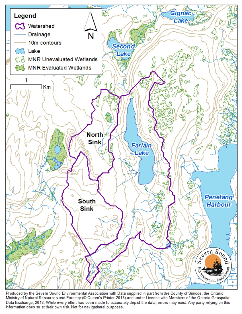
Watershed Map Provided Courtesy of the Severn Sound Environmental Association (SSEA)
Lake Water Levels
Farlain Lake is a kettle lake that was formed during the last glacial period. It is unique in that it has no surface discharge, classifying it as a seepage kettle lake. The lake is mainly groundwater fed and is in a groundwater recharge zone, with a groundwater fed tributary that flows year round into the lake. Several other tributaries flow into the lake on an intermittent basis as a result of precipitation. It is suspected that Farlain Lake slowly discharges to Second Lake via groundwater flow. Not having an outlet can lead to high water levels in years with greater than average precipitation, while steady groundwater inputs prevent abnormally low water levels in years with less precipitation.
Changes in Water Levels
Water levels at Farlain Lake have risen steadily over the past 8 years, with a substantial increase since 2016. The highest level was experienced in 2019 and the level as of the spring of 2023 is close to the same. Higher water levels are of particular concern to shoreline property owners and particularly those on lower lying properties around the east and south shorelines who have experienced flooding over the past few years. In 2023, a detailed report was prepared by Aisha Chiandet, Water Scientist at the Severn Sound Environmental Association (SSEA), based on data collected with the installation of a water level gauge in 2019 and monitoring by FLCA volunteers working with the SSEA. Download the full report here Lake Water Level Update from SSEA May 2023.
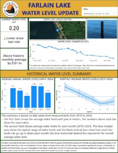
Farlain Lake Water Level
During the summer of 2025, the SSEA, with the support of Tiny Township, worked with FLCA citizen scientists to collect water level measurements and produce a monthly report which was then posted to the SSEA web site and made immediately available to the lake community through signs posted at the boat launch and north end of the lake. The summary of those reports is seen on the left here. The collection of data through the gauge allows the SSEA to compare it to corresponding weather and precipitation at the corresponding times in an effort to understand the correlation.
Lake water levels are determined by the balance of water inputs and outputs. For Farlain Lake, inputs include precipitation, inflowing tributaries and groundwater, and surface runoff. Outputs include evapotranspiration by plants, evaporation from the lake’s surface, and discharge via groundwater. Changes in precipitation and timing/intensity of snow melt may have a large impact on water levels in the lake, especially since there is no outflow. The impact will be determined partially by the local geology/physiography, so this along with information on precipitation, and timing/intensity of snow melt are important to consider in determining possible causes of increased water levels.
The increases in water levels observed on Farlain Lake are likely related to changes in precipitation and snow melt. An increase in snow melt could be a result of an increase in snowfall amount and/or warmer days earlier in the season that cause the snow to melt all at once instead of over a longer period of time. The fact that there is no outlet from the lake would impact the response of the lake to precipitation/runoff/snow melt events. This impact would result in higher water levels as all the inputs are stored within the lake then slowly discharged via groundwater, the speed of which depends on local geology. Based on the local geology, it is expected that any precipitation would result in large water level increases as the lake receives runoff from a large catchment relative to the lake’s size. Due to the sandy nature of the surface geology around Farlain Lake, this runoff and shallow groundwater may flow quickly to the lake, resulting in a larger total amount of precipitation entering the lake over a shorter time period. However, the silt and clay-rich layer underlying the lake would result in slow discharge of the water from Farlain to Second Lake. Therefore, larger water level increases following precipitation would be expected as a result of the local geology. If increased precipitation events are occurring recently (precipitation events that are higher intensity or longer lasting etc.), then these may be a big contributor to the higher water levels within the lake over time.
Other impacts on the lake level include the significant increase in development that has occurred around the lake with the increase in the number of occupied properties, an increase in the number of full season residents compared to seasonal, the change in structures from the small original cottages to larger more permanent buildings. Correspondingly there is an increase in septic systems and water usage and the removal of shoreline vegetation that previously had helped absorb run-off.
The Impact
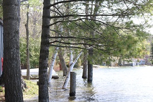
 Higher water levels are of particular concern to shoreline property owners especially those on lower lying properties around the southeast and south end of the lake. The boat launch area is at the lowest point on the lake and the most severely affected. Impacts include:
-
- loss of property, particularly beaches
- death of old mature trees along the shoreline posing a safety hazard and incurring significant expense for removal
- impact on septic systems resulting in the need for moving them or installation of holding tanks
- flooding and damage to structures such as boat houses along the shore
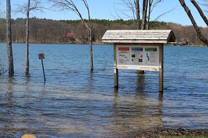
- difficulty using the boat launch (photo on the right shows the launch area in spring)
How Can We Deal With This Challenge?
Unfortunately there is no magic bullet in developing a strategy to address the increased levels. All lakes evolve naturally and Farlain Lake is not the lake it was when many of us came here over 60 years ago. So many factors are affecting it – natural evolution, climate change, the significant development that has occurred around the entire lake’s shoreline with additional ongoing development in the surrounding areas within the lake’s watershed. Information published re the impact of climate change indicates that the swings in water levels from high’s to low’s will be more extreme and the high’s will be higher than in the past and the low’s lower. There will be more extreme intensive storms and rainfall, shorter ice cover periods (which means a longer growing period for plants in the water like the EWM), warmer air temperatures creating warmer water temperature, and the list goes on.
There are actions that property owners can take. Plant trees along the shoreline that are water tolerant. The Gardening Knowhow web site offers advice as to what species are more water tolerant. However these species also have very extensive root systems so care is needed where the trees are located near septic systems. Excellent resources for property owners in managing the impact of the high water level and flooding are two publications by the Federation of Ontario Cottage Associations (FOCA) of which the FLCA is a member – they can be downloaded from the FOCA web site under Publications: Managing Your Waterfront Property in a Changing Climate and Shoreline Owners’ Guide to Healthy Waterfronts.
The FLCA will continue working with the SSEA and the Township to monitor the changes, continue trying to understand the changes in the lake, continue sharing information and education with the community. It has been suggested that the water level of the lake be artificially controlled with some type of drainage. There are a whole host of challenges to that including the potential impact on the environment, the cost, Awenda Park’s position that there will be no drainage through the Park from the north end of the lake, who would be responsible, and the fundamental question of what is the “right” level for the lake? The answer to that will be very diverse depending on the location on the lake. Much time and energy has been spent on this issue and the challenges include:
-
- MECP, through the Awenda Park Superintendent, has indicated in no uncertain terms that in accordance with the Parks and Conservation Act regulations there will be no drainage from the lake at the north end into Second/Kettle Lake through the Park;
- MECP and the Park are fully aware of the EWM in the lake;
- DFO and MNRF must approve any work done in any body of water containing fish and that approval would require submission of data/studies we don’t have;
- Hydrogeology studies are extremely expensive and the Township will not commit resources to undertaking them at present;
- SSEA will not support any artificial alteration to the drainage of the lake.
Spring 2026
The spring of 2026 saw the highest lake water level in memory. This has had a significant impact on the community as a result of the damage due to flooding around the lake. As a result, a dedicated page on this web site under Our Lake/2026 High Water Level has been set up to ensure that the members of the lake community are kept as informed as possible as to the impact and the work that is being undertaken to address this serious issue. Please check it out regularly.